It's been almost three months since we left on our Spring Break trip to Scotland, but in the blogging world it's better late than never!
We flew into Edinburgh and took the train into town. We had this view of the castle rolling in.
Our hostel was right on the street with the castle! We walked out the door to see it from this angle.The grass in Scotland is definitely different than the Kentucky Blue Grass we have in Minnesota, it seems like the Scots can keep it a brilliant green year-round.
We did a lot of walking, eating, and drinking in the city for a few days. This is the Cathedral in the main square. It was built as a Catholic church (and definitely looks it) but was taken over by the Protestants during the reformation. There was apparently a thrilling protest to the change involving the throwing of many stools at the priest.
What amazed me most about Scotland was that, despite the often dour weather, nearly every view was picturesque. This was a walk we took through a graveyard on our first day in town.
The bar scene in Edinburgh is great. We ran across a small music bar called Captains that has made me so very excited to go to Ireland later this summer. I could have stayed in this bar all week.
Hiking Arthur's Seat was a nice way to get out of the city streets for a few hours. It's an old volcanic formation that gives great views of the city.
Our crew at the top! It was crazy windy. From left to right: Jimmy, me, Andrew, and Stuart. We're all high school buddies and you may recognize them from prior travels.
I would be remiss in not thanking Sara Lewis for her spectacular food recommendations in Edinburgh and around. This cafe, Dovecot, situated in an art gallery had maybe the best sandwiches we've ever eaten. We talked about them for the rest of the trip.
We took her recommendation to try Haggis as well. It's a Scottish traditional food made by grinding up all kinds of strange parts of a sheep. Stu had it several times, I think I was happy with trying it once. Parsnips and potatoes underneath make the dish "haggis, neeps, and tatties".
Our car! Driving was interesting considering it happens on the left side of the road.
Admittedly, Andrew did a better job than I did with the switch. After a few U-Turns I ended up driving on the wrong side once or twice. It took some getting used to, but since everything is backwards it wasn't so bad.
Our first stop outside of the city was a hike that my tour book recommended to a spot called "The Hermitage". A bonus was the tallest tree in the UK along the trail!
The Hermitage was pretty cool. The McGregor Clan was attempting to expand their territory with this little retreat complete with a stone arch bridge and a little building overlooking a waterfall.
I could definitely see coming out here and listening to nature to get away from life for a while. This was such a great hike right off the side of the highway.
As we continued to drive North, I began to see why there is such a mysterious culture surrounding the lochs of Scotland. They're pretty eerie.
We rolled up to Loch Ness in the evening and stayed at a lovely B&B in a town called Foyers. They're known for a series of waterfalls dropping into this channel heading to the loch. Can you see the monster?? Yeah, we didn't either.
The falls of Foyers! There were several little drops like this leading down to the loch.
One of Jimmy's goals was to find a stuffed Nessie doll. It wasn't a problem.
The beers we tried in Scotland weren't fantastic. Most were poured from a cask and the flavors weren't awesome. The Loch Ness Brewery was pleasantly different. They had good selection and this amber ale was great.
We saw a lot of castles. This one was on the West side of Loch Ness and we caught it on the way out of town.
This is the kind of stuff I love finding when you're just driving across a new country. It's a beautiful arched rail bridge stretching across sheep grazing land. Cool stuff!
The damp weather made pubs with fires especially attractive. We found plenty of them in the highlands!
The further North we traveled, the more serene the landscape became. More snow-capped mountains and perfectly smooth lochs. Breathtaking.
The Scottish Highlands were created when Scotland's tectonic plate smashed into the rest of the UK. Our walking tour guide in Edinburgh told us that the plate will continue sliding North and will eventually (billions of years) separate from the UK once again.
We saw a whole lot of wildlife along the road. It sounds like motorists hit these stags all winter long, thankfully we got to enjoy them without their jumping in front of our car.
This was probably the best-set castle we stopped to see. Set out on a point with an arched bridge and mountains in the background. Definitely worthy of a group pic.
When we reached the Isle of Skye our first destination was Elgol way out on one of the Western points. We stopped at a little inn for lunch and had potted squat lobsters that had been pulled out of the water that morning. They were so so very good, and they use all local vegetables and make their own bread. We also had beer from the local Skye brewery. Awesome awesome meal.
Shaggy cows! Mom told me to get a picture with one. Here you go!
We got about as remote as you can get on Skye. We stayed on the Northern tip and did some hiking in the area. It's sobering to see this wide-open land empty out into the sea.
As I said before, the driving on the left wasn't a huge deal, but the one-lane roads took some more getting used to. Pretty much everywhere in the highlands had one-lane roads with little turn-outs to allow passing every fifth of a mile or so. Driving definitely required concentration.
One of the Isle of Skye attractions are the Fairy Pools. It's a series of these little waterfalls dropping down with huge mountains in the background. Made for a pretty cool hike.
On our way off the island we stopped at a little viewpoint. I was the only one that got out of the car since it was starting to rain, but got to see some pretty cool cliffs.
And this waterfall falling right into the ocean. Pretty cool! I don't think I've ever seen anything like that before.
Our last stop of the trip was Loch Lomond in the Trossachs of Scotland. This is definitely where the tourists go; it's closer to Edinburgh than the rest of the highlands, so we called it "highlands lite". We stayed at this awesome B&B that gave us a great deal since it was the very beginning of their season.
My mom would love this place. They collect stuff from all over the world but it isn't crowded, and their gardens are beautiful. Plus they are right on the loch, there are great views from the rooms.
Being so close to the loch and it being Spring Break and all, Stu and I figured we had to go swimming.
I especially like the gloomy background. Perfect swimming weather, right?
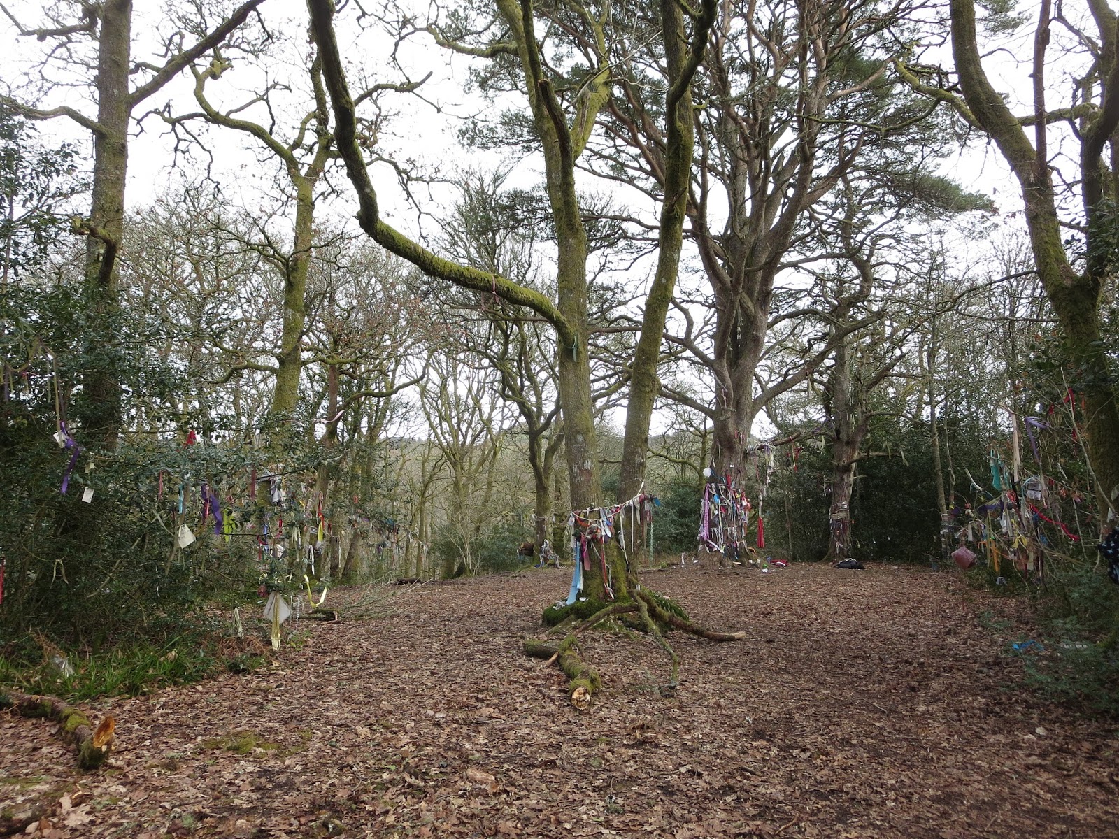
We took our time driving back to Edinburgh since we had the whole day. Doon Hill is a popular spot for tourists, there are supposed to be fairies that live at the top. Apparently a famous fairy researcher did lots of work here. It also made for a cool hike.
There are all kinds of ribbons tied to the trees at the top. Wishes for good luck and blessings in life.
Although it's quite the journey to get there, anyone visiting Scotland should try to make it out to the Monachyle Mhor Inn at least for a meal if not to stay. It's at the very end of this long (yes, one-lane) road but it's so worth it. It's on this gorgeous loch all by itself and the food is awesome. It was also the best beer we found in Scotland.
Our last night was spent back in Edinburgh close to the airport. It was Holy Saturday so I walked a couple miles to the local Easter Vigil. We were treated to the best sunset of the trip on the way. What a beautiful way to end a great trip!
Huge new adventures coming up. Come back in August (or a little later, I'll do my best!) to hear about Africa and Europe!
Hey everyone! Good to be back with an exciting trip. Lots of pictures, so I'll try to keep the words brief.
Last week I had a great trip to Phoenix for a conference on PLCs (Professional Learning Communities). This image captures the general idea: why have every teacher take on their challenges alone when we could work together to figure out how to best achieve student learning? It was great, I learned a lot!
Our second night, a group of us climbed Camelback Mountain just East of downtown Phoenix. It was a beautiful climb, and even though we were pushing the limit in terms of daylight, the sunset was absolutely beautiful.
A few of our team from EHS on the way down.
We finished on Friday at noon. I jumped right into a rental car and headed North. I took a detour through the Oak Creek Canyon.
Sedona is absolutely beautiful. The red color of the rocks is fantastic.
The rental company gave me a treat. I got to drive this Mercedes E Class all weekend. It was a very fun car to drive.
After puttering through the Oak Creek Canyon I continued North on 64 for the big guy.
My first view of the canyon is the only one that most tourists see. The visitor center on the South Rim runs right up to Mather Point where I stopped for the sunset on Friday night.
I didn't see any spectacular sunsets or sunrises as far as the colors in the sky are concerned, but the colors in the canyon come alive during these times of day. Nature is incredible.
Sunrise on Saturday morning, again from Mather Point.
I had put my name on a waiting list to stay at the bottom of the canyon Saturday night and got good news early Saturday morning: they had a spot! So my plan was to go down Kaibab on Saturday and back up Bright Angel (the more popular trail) on Sunday.
Kaibab was built with one purpose: get to the bottom as quickly as possible. The views are spectacular, but you're on switchbacks nearly the entire time. The first mile or so had snow on it, lots of people had added traction on their boots.
The thing I liked about Kaibab was that the view changed frequently. This is what we had for the first couple miles. I can think of worse things to look at.
It's well-known that the South Kaibab trail has absolutely no drinking water available. There are signs like these two consistently on the trail. I had done lots of research and was well-prepared. You're welcome, Mom :)
The size of this thing is ridiculous. I can't believe that erosion and a little river were able to cause such an awesome canyon.
Considering all the horror stories about people getting lost or falling, I found some hiking buddies. Eric, Jason, and Sophia were my downward companions.
Here are Eric and Jason, father and son. They do a lot of hiking together. Jason goes to Duke, who Notre Dame just beat in the ACC division tournament. Go Irish! Sorry, Jason.
Speaking of Jason, he made a great video of our hike using his go pro. Check it out here if you want to take a look!
A new view! The colors became more red as we descended.
This gives you an idea of the switchbacks we were dealing with. I'm glad I didn't come back up the same way I went down.
We passed a few mule trains on the way down. This is how everyone entered and left the canyon when tourism became big in the early 1900s. I prefer to walk.
The trail cut into dark red sandstone as we continued to descend. I love that color.
Eventually the river came into view and we could see the bridges that cross connecting the South side to the North.
The "Black Bridge", just visible in this picture, was constructed in 1928. Most parts were carried down by mule but the cables were too long and had to be hiked down on the shoulders of workers.
These mules were carrying trash and duffel bags for people who didn't want to carry their stuff. $68 for 30 pounds of gear. I prefer to get the workout.
Another view of the black bridge. I love how it goes right into a tunnel. I'm very curious about how they decided to put the trail in this location. I'm sure lots of planning went into it, but it seems like it was a tough place to put it.
...or the mules will eat your sign.
Phantom Ranch was a welcome sight after about 5 hours of hiking. They have cabins, dorms, running water, food, and anything else you'd want after a day of hiking. They had plenty of extra space (read: even though Phantom Ranch books solid 13 months in advance, you can almost always get a bed day-of, just check in at Bright Angel Lodge in the morning) so Jason and Eric abandoned their camping idea and opted for beds.
This is the dining hall. I love the look of this place, Mary Colter did a great job designing it. She did several of the buildings in the park.
Lots of rafters stop to stay at Phantom Ranch as well. The boat beach was one of the reasons this location was so attractive to the first explorers who floated the river. There is also a beautifully clear creek, Bright Angel Creek, that flows right past camp.
There were signs everywhere that said swimming is dangerous due to the current and cold temperature of the water.
(repeat readers know where this is going...)
So of course I went swimming.
The spot right off the beach was very calm, almost no current at all. The water was definitely cold, but warmer than the lakes in Patagonia.
Since we started out so early in the morning, we had plenty of time to do some exploring outside the ranch in the afternoon. This is the Clear Creek Trail up the North side. I love the color of the trees above Bright Angel Creek. An orchard and several gardens were planted by the first people to make camp here around 1900.
The first thing I noticed about the Clear Creek Trail was that the cacti grow right on top of the trail. Definitely no mules on this one. It would hurt to run into one of these.
We had a beautiful viewpoint where we turned around on the Clear Creek Trail. I would have loved to have been up here for sunset but dinner time got in the way.
There were deer all over camp, and they weren't shy at all.
Dinner was great. A big steak, and I even ate the potato. I needed the calories.
They also had beer at the bottom. I was quite impressed with the operation they run at Phantom Ranch considering everything is packed in on mules.
The sun went out of view long before sunset considering how low we were, but the colors on the East canyon wall were beautiful long after it was gone.
Here's a view toward the West. As I said, no spectacular colors in the sky, the big story was the rocks looking in the other direction.
I got a very early start on Sunday morning, well before sunrise. I had to be back to Phoenix in time for my flight at 6 p.m. and some doubted that I'd make it. I snapped this picture about an hour or so after I started, it was just starting to get light.
I was very focused on getting out quickly, so I didn't take many pictures on the way up. The view remained relatively constant, I was just able to see further across as I ascended.
They have a rest house at 3 miles from the top and another at 1.5 miles. Since lots of less serious hikers give this trail a shot, there are lots of logical "turnaround" points. At each one there are lots of signs warning hikers to know their limits.
The sun! I only had it for about 30 seconds on my entire hike up, otherwise it was hiding behind the canyon wall.
After getting a little higher I wanted to take a picture of the only switchback on the entire trail where I could see the sun. I think if I had started 15 minutes earlier that I wouldn't have seen it until I got to the rim.
There are two tunnels cut into the rock close to the top, more turnaround points for hikers that only want to drop a bit below the rim.
The trail near the top was very slick, it hardly ever sees the sun. I can see how it would be discouraging to descend on this trail at the beginning.
I made it out in 4 hours. I was hoping for 6 or less, so it was a pleasant surprise.
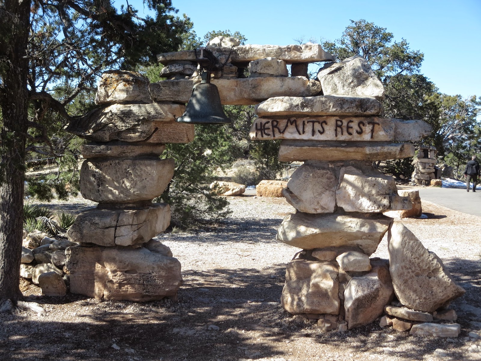
I had extra time, so I hopped on a shuttle heading West to Hermit's Rest.
Named for the spot where backpackers stop to rest before descending Hermit's Trail into the canyon, it's now a beautiful little gift shop.
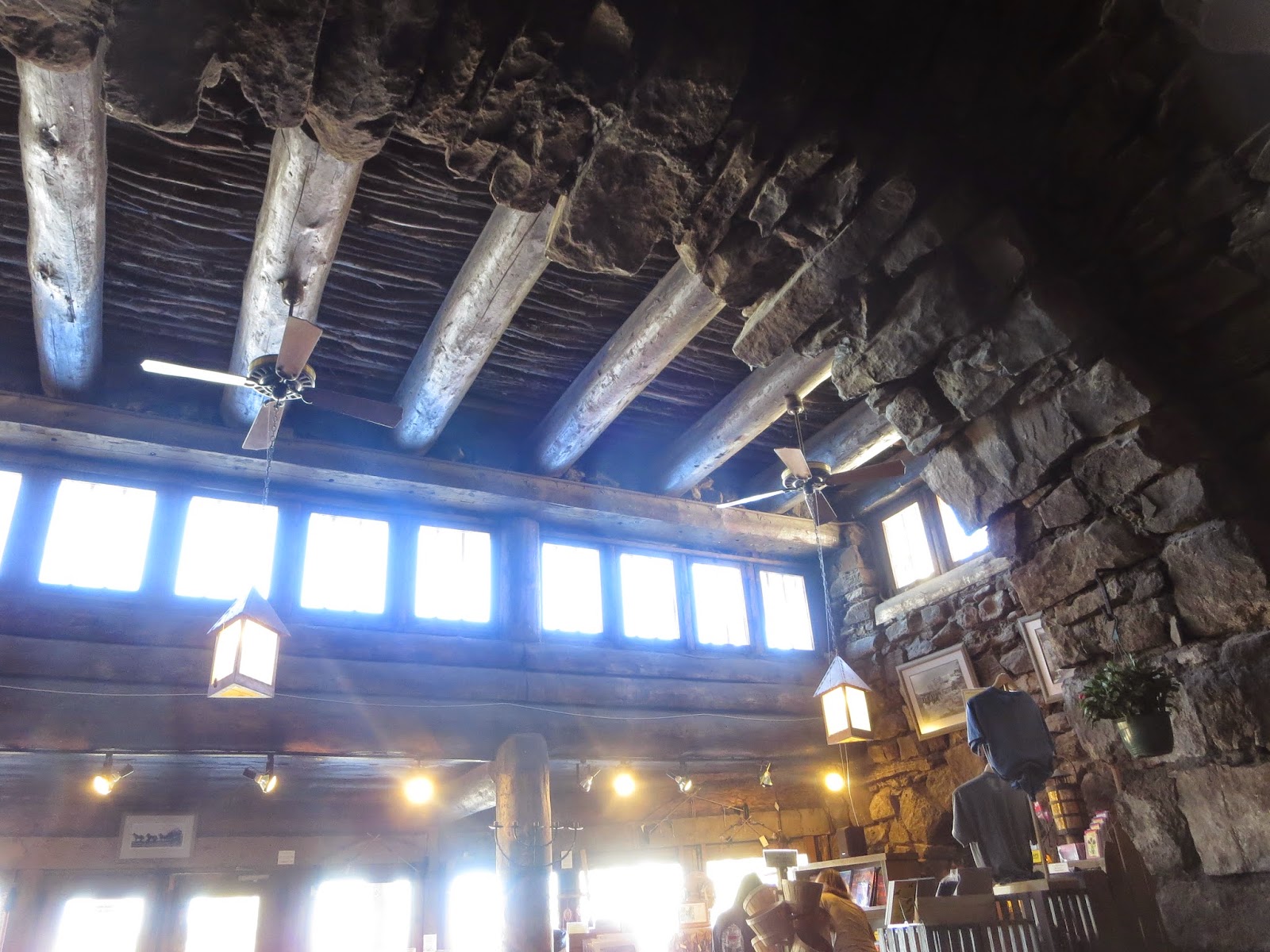
Another Colter building, it looks like it emerges right out of the hill. Colter wanted it to look like someone had built it using only what they could find, and she definitely achieved that look.
The interior is just as beautiful. Lots of rocks and hand-carved furniture.
I love the mix of wood and stone.
The view from Hermit's Rest is great too. Those long spires point to the river and to three sets of rapids that are notorious for flipping rafts. They call this formation the Tower of Ra because Ra was the Egyptian god who was always victorious.
After returning to my car I drove out on the Desert View Highway to the East to see my final views of the canyon. This is Grandview Point, the former location of a giant hotel and a copper mine down on Horseshoe Mesa, seen here.
The second stop was Moran Point where you can easily see the Sinking Ship, dead center in this picture. It looks like it's sinking downward from left to right.
Look at those colors! This portion is called the Red Canyon with good reason.
Lipan Point, a spot where I could see the most of the canyon at one time, I think. I'm so amazed at the expanse of this thing.
Desert View Tower, another Colter creation. It's modeled after a Hopi watchtower and has all kinds of Hopi art inside.
It also offers great views. These cliffs extend out to where the canyon begins to the East.
That mesa that looks out-of-place has some of the only rock that isn't sandstone in the canyon. Deposited millions of years before the sandstone, it has stood the test of time.
My final view of the canyon, looking West from Desert View Tower. I'm so glad I had this great opportunity to see such a massive feat of nature, and I feel like I only saw a small portion of it. I hope to go back someday to raft the river so I can see it all from top to bottom!